Providers that serve an area, not an address
An HVAC technician based fifty miles away may cover the visitor's whole county. An installer serves three states from one depot. Sorting those by distance from their office tells the visitor the wrong thing. A service-area locator shows who serves the visitor's location, and draws where.
Two tools cover it, and they combine: a service radius on each provider, which the map draws and distance search respects, and territories by postcode for the cases where the agreement is written in postcodes rather than miles.
1. Add providers as service areas
- 1
Choose the type
When adding a location, pick Service area as the location type. It keeps a centre point (the office, or the middle of the patch) and a radius. - 2
Set the radius
The coverage radius in kilometres. The map draws it as a circle rather than a pin, so a visitor sees the patch, not a shop. - 3
Tag the specialties
Heating, plumbing, solar, emergency call-out: tags become the filter a visitor uses to find the right kind of provider. See categories and filters.
A CSV can carry the type and radius as columns (service area in the location type column), and a synced Google Sheet or Airtable keeps them current.
2. Make search answer "who serves me"
Under search settings, keep the place search on and the radius selector on, so a visitor types a postcode and narrows to providers within a distance. With Radius marker visibility on, the map shows only the providers whose circles reach the visitor. Sort by distance, so the closest depot lists first among those who cover the visitor.
For providers whose coverage is a list of postcodes rather than a circle, add territories as well. Territories in Fallback mode add the owning provider when nothing within the radius covers the visitor, and in Preferred mode pin them first; the dealer locator guide walks through it.
3. Let the visitor book or enquire
Field-service businesses take enquiries rather than walk-ins. Turn on the Enquiry form: after a search the visitor sends a message, it is routed to the provider whose territory covers the address (or the nearest one), and it lands under Leads and in the provider's inbox. A booking link per provider is a custom field placed as a button; the appointment booking guide shows the steps.
What the visitor sees
Rivet Plumbing is an example locator built this way. Six crews, no shopfronts, each drawn as a coverage circle rather than a pin, and the first action on every card is the phone call.
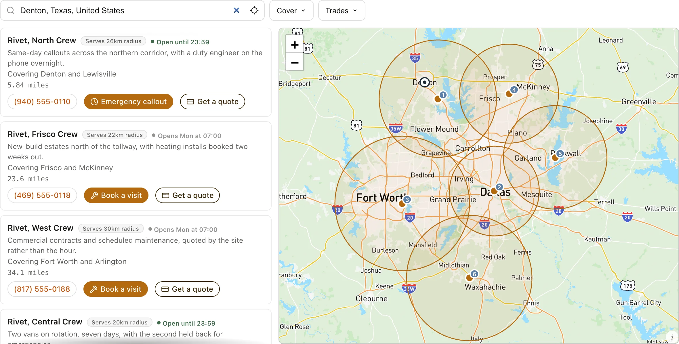
Circles rather than pins for service areas, pins for any storefront in the same network, the list narrowed to those who reach the visitor, and a Contact or Book button on each. Hide the map entirely with a list-only layout if circles are more confusing than helpful for your visitors; the search and filters work the same without it.
Drawn areas and what is not here
An area drawn on a map is a Spotlight rule: draw the coverage, and either feature the providers who serve it or show only them. Spotlight decides what is shown; it does not route an enquiry, which stays with territories. Counties and states cannot be picked by name in either place; an agreement written as a region has to be drawn or written as postcodes.